Perseverance Rover's Striking Selfie Unveils Mars' Ancient Landscape
NASA's Perseverance rover has captured a breathtaking new selfie from its perch on the western rim of Jezero Crater, offering a window into Mars' ancient history. The image reveals rugged cliffs and terrain that hold clues to the planet's past. In this Q&A, we explore the details behind this remarkable photograph and what it tells us about the Red Planet.
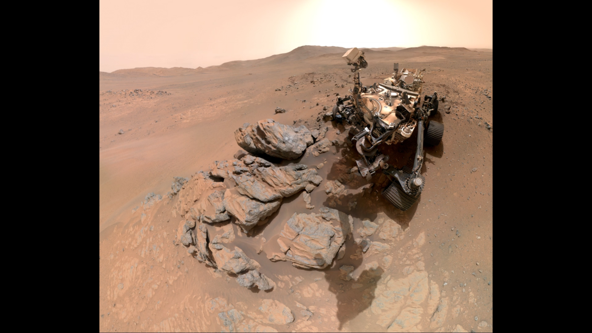
1. Where exactly did Perseverance take this new selfie?
The selfie was captured from the western rim of Jezero Crater, a site chosen for its ancient geological significance. Jezero Crater once hosted a lake and river delta billions of years ago, making it a prime location to search for signs of past microbial life. The rover was perched along a rugged section of the rim, providing a sweeping view of the crater's interior and the layered cliffs that record Mars' climatic history. This vantage point gives scientists a unique perspective on the transition from the crater floor to the surrounding highlands. The selfie not only showcases the rover but also frames the distant Martian horizon, emphasizing the harsh yet beautiful environment Perseverance explores.

2. What does the selfie reveal about Jezero Crater?
The image highlights fractured cliffs and ancient terrain that are key to understanding Mars' watery past. The cliffs show distinct sedimentary layers, likely deposited by water flows when the crater was a lake. Some areas exhibit erosion patterns that hint at past wind and water activity. The selfie also captures the dramatic contrast between the crater's rim and the smoother interior basin. These features provide valuable context for the rover's samples, which will eventually be returned to Earth. By studying these rock formations, scientists hope to unravel the chronology of Martian climate change and assess whether the environment was ever habitable for life.
3. How does the rover take selfies on Mars?
Perseverance uses its robotic arm equipped with the WATSON camera (Wide Angle Topographic Sensor for Operations and eNgineering) to capture multiple images that are stitched together into a mosaic. The rover's arm extends the camera to a height that mimics a human holding a smartphone. Because the camera is on the arm, the images don't include the arm itself—similar to how you might take a group photo with a selfie stick. The process involves taking dozens of overlapping shots, which are then sent to Earth for processing. This technique allows the rover to document its surroundings and itself in high resolution, providing both scientific data and public engagement imagery.
4. Why is this selfie considered "dramatic"?
The term "dramatic" stems from the stark, rugged beauty of the landscape combined with the rover's precarious perch. The selfie shows Perseverance against a backdrop of steep, fractured cliffs that drop into the crater below. The lighting conditions—likely captured during the Martian afternoon—create long shadows that accentuate the terrain's texture. Additionally, the image captures the rover's dusty solar panels and wheels, reminding viewers of the harsh conditions it endures. This composition evokes a sense of adventure and isolation, making it one of the most visually compelling selfies from Mars to date. The contrast between the machine and the wild environment underscores the human achievement of exploring another world.
5. What scientific clues does the terrain hold?
The fractured cliffs and layered rock visible in the selfie are rich in mineralogical and sedimentary clues. Scientists can identify carbonates, clays, and sulfates from afar using the rover's spectrometers, but the selfie provides visual context for these detections. The layers represent different geological epochs, each recording changes in water chemistry, temperature, and sediment supply. For example, certain rock types may indicate alkaline lakes, while others suggest acidic conditions. By correlating the selfie's features with data from Perseverance's instruments, researchers can reconstruct the ancient environment and target the most promising rocks for sample collection. These samples could eventually reveal whether organic molecules or biosignatures exist.
6. How does this selfie compare to previous ones?
Earlier selfies, such as the one taken shortly after landing, focused on the crater floor and the rover's first tracks. This new selfie offers a wider, more panoramic view from a higher elevation. Previous images emphasized the flat, rocky terrain, while this one highlights the vertical relief of the crater rim. The perspective is also different: the rover is positioned so that the sun backlights the cliffs, creating a more dramatic effect. Compared to the selfie technique used by the Curiosity rover, Perseverance's camera has a higher resolution and better color calibration, producing sharper images. This progression reflects the rover's journey from the landing site into more geologically complex areas, each selfie marking a milestone in its exploration.
Related Articles
- Mastering Long-Horizon Planning: A Step-by-Step Guide to GRASP
- Eta Aquarid Meteor Shower Peak: How to See Shooting Stars Despite the Moon's Glare
- Understanding the Amazon's Rainfall Tipping Point: A Step-by-Step Guide to How Deforestation and Climate Change Interact
- Unraveling Word2Vec: How a Simple Neural Network Learns Word Embeddings Step by Step
- Navigating the AI Efficiency Trade-Off: Preserving Team Bonds When Automation Removes Informal Interactions
- How to Diagnose Multi-Agent System Failures: A Step-by-Step Guide to Automated Failure Attribution
- Amateur Astronomer's Breathtaking Image Reveals Pleiades Cluster Shrouded in Icy Blue Nebula
- How to Contain a Wildfire in a Radioactive Exclusion Zone After a Drone Crash